[Earth as Art] (in Hi-Res)


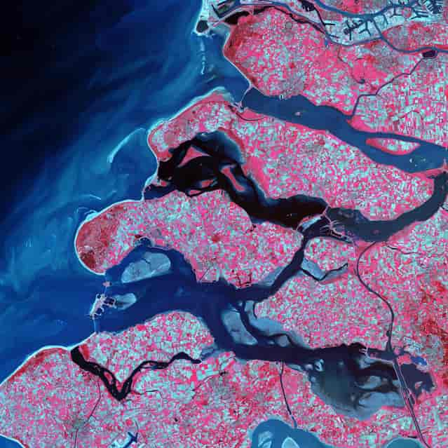
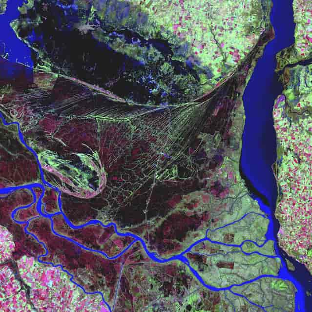
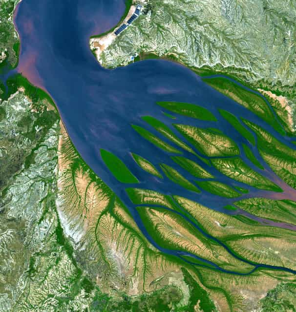
    Bombetoka Bay, Madagascar. On the northwestern coast of Madagascar, the salty waters of the Mozambique Channel penetrate inland to join with the freshwater outflow of the Betsiboka River, forming Bombetoka Bay. Numerous islands and sandbars have formed in the estuary from the large amount of sediment carried in by the Betsiboka River and have been shaped by the flow of the river and the push and pull of tides. This image from the Advanced Spaceborne Thermal Emission and Reflection Radiometer (ASTER) on NASA's Terra satellite shows Bombetoka Bay just upstream of where it opens up into the Mozambique Channel, which separates Madagascar from Africa to the west. In the image, water is sapphire and tinged with pink where sediment is particularly thick. Dense vegetation is deep green. Along coastlines and on the islands, the vegetation is predominantly mangrove forests. In fact, Bombetoka Bay is home to some of Madagascar's largest remaining communities of mangroves, which provide shelter for diverse mollusk and crustacean communities, as well as habitat for sea turtles, birds, and dugongs. Along the northwest coast of Madagascar, mangroves and coral reefs partner up to create dynamic, diverse coastal ecosystems. The mangrove forests capture river-borne sediment that would smother coastal reefs, while reefs buffer the mangroves from pounding surf. (Photo by NASA/GSFC/USGS EROS Data Center)


    Bombetoka Bay, Madagascar. On the northwestern coast of Madagascar, the salty waters of the Mozambique Channel penetrate inland to join with the freshwater outflow of the Betsiboka River, forming Bombetoka Bay. Numerous islands and sandbars have formed in the estuary from the large amount of sediment carried in by the Betsiboka River and have been shaped by the flow of the river and the push and pull of tides. This image from the Advanced Spaceborne Thermal Emission and Reflection Radiometer (ASTER) on NASA's Terra satellite shows Bombetoka Bay just upstream of where it opens up into the Mozambique Channel, which separates Madagascar from Africa to the west. In the image, water is sapphire and tinged with pink where sediment is particularly thick. Dense vegetation is deep green. Along coastlines and on the islands, the vegetation is predominantly mangrove forests. In fact, Bombetoka Bay is home to some of Madagascar's largest remaining communities of mangroves, which provide shelter for diverse mollusk and crustacean communities, as well as habitat for sea turtles, birds, and dugongs. Along the northwest coast of Madagascar, mangroves and coral reefs partner up to create dynamic, diverse coastal ecosystems. The mangrove forests capture river-borne sediment that would smother coastal reefs, while reefs buffer the mangroves from pounding surf. (Photo by NASA/GSFC/USGS EROS Data Center)


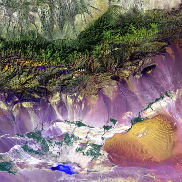
    Bogda Mountains. The Turpan Depression, nestled at the foot of China’s Bogda Mountains, is a strange mix of salt lakes and sand dunes. It is one of the few landscapes in the world that lies below sea level. This image was acquired by Landsat 7’s Enhanced Thematic Mapper plus (ETM+) sensor. (Photo by NASA/GSFC/USGS EROS Data Center)


    Bogda Mountains. The Turpan Depression, nestled at the foot of China’s Bogda Mountains, is a strange mix of salt lakes and sand dunes. It is one of the few landscapes in the world that lies below sea level. This image was acquired by Landsat 7’s Enhanced Thematic Mapper plus (ETM+) sensor. (Photo by NASA/GSFC/USGS EROS Data Center)


    Meandering wadis combine to form dense, branching networks across the stark, arid landscape of southeastern Jordan. The Arabic word [wadi] means a gulley or streambed that typically remains dry except after drenching, seasonal rains. This scene was acquired by the ASTER instrument on NASA's Terra satellite on May 17, 2001. (Photo by NASA/GSFC/USGS EROS Data Center)


    Meandering wadis combine to form dense, branching networks across the stark, arid landscape of southeastern Jordan. The Arabic word [wadi] means a gulley or streambed that typically remains dry except after drenching, seasonal rains. This scene was acquired by the ASTER instrument on NASA's Terra satellite on May 17, 2001. (Photo by NASA/GSFC/USGS EROS Data Center)


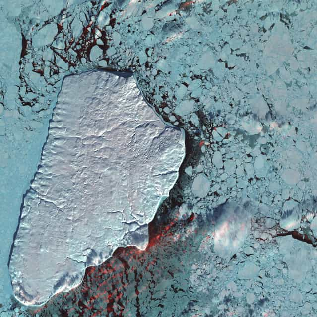
    Akpatok Island, Canada. Akpatok Island lies in Ungava Bay in northern Quebec, Canada. Accessible only by air, the island rises out of the water as sheer cliffs that soar 150 to 243 m above the sea surface. Akpatok Island is an important sanctuary for cliff-nesting seabirds. Numerous ice floes around the island attract walrus and whales, making Akpatok a traditional hunting ground for native Inuit people. Image taken January 22, 2001, by Landsat 7. (Photo by NASA/GSFC/USGS EROS Data Center)


    Akpatok Island, Canada. Akpatok Island lies in Ungava Bay in northern Quebec, Canada. Accessible only by air, the island rises out of the water as sheer cliffs that soar 150 to 243 m above the sea surface. Akpatok Island is an important sanctuary for cliff-nesting seabirds. Numerous ice floes around the island attract walrus and whales, making Akpatok a traditional hunting ground for native Inuit people. Image taken January 22, 2001, by Landsat 7. (Photo by NASA/GSFC/USGS EROS Data Center)


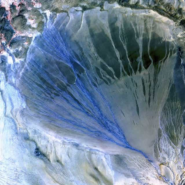
    Alluvial Fan, China. A vast alluvial fan blossoms across the desolate landscape between the Kunlun and Altun mountain ranges that form the southern border of the Taklimakan Desert in China’s XinJiang Province. Image taken by the ASTER instrument on NASA’s Terra satellite on May 2nd, 2002. (Photo by NASA/GSFC/USGS EROS Data Center)


    Alluvial Fan, China. A vast alluvial fan blossoms across the desolate landscape between the Kunlun and Altun mountain ranges that form the southern border of the Taklimakan Desert in China’s XinJiang Province. Image taken by the ASTER instrument on NASA’s Terra satellite on May 2nd, 2002. (Photo by NASA/GSFC/USGS EROS Data Center)


    Delta Region, Netherlands. Along the southern coast of the Netherlands, sediment-laden rivers have created a massive delta of islands and waterways in the gaps between coastal dunes. After unusually severe spring tides devastated this region in 1953, the Dutch built an elaborate system of dikes, canals, dams, bridges, and locks to hold back the North Sea. Image taken on September 24, 2002, by the ASTER instrument aboard NASA’s Terra satellite. (Photo by NASA/GSFC/USGS EROS Data Center)


    Delta Region, Netherlands. Along the southern coast of the Netherlands, sediment-laden rivers have created a massive delta of islands and waterways in the gaps between coastal dunes. After unusually severe spring tides devastated this region in 1953, the Dutch built an elaborate system of dikes, canals, dams, bridges, and locks to hold back the North Sea. Image taken on September 24, 2002, by the ASTER instrument aboard NASA’s Terra satellite. (Photo by NASA/GSFC/USGS EROS Data Center)


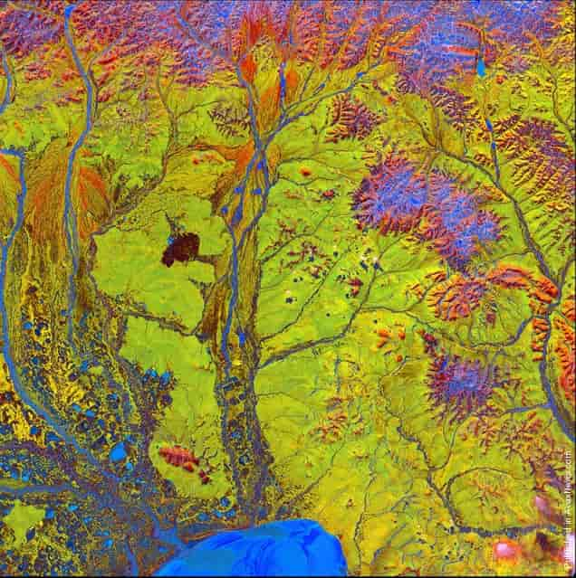
    Yukon Delta. After beginning in northern British Columbia and flowing through Yukon in Canada, the Yukon River crosses Alaska, USA, before emptying into the Bering Sea. Countless lakes, sloughs, and ponds are scattered throughout this scene of the Yukon Delta. The river’s sinuous waterways seem like blood vessels branching out to enclose an organ. The Yukon Delta is one of the largest river deltas in the world, and currently protected as part of its own National Wildlife Refuge. This image, taken by Landsat 7 on September 22, 2002, won 2nd place in the online [Earth as Art] competition to celebrate the 40th anniversary of the Landsat satellite program. (Photo by NASA/GSFC/USGS EROS Data Center)


    Yukon Delta. After beginning in northern British Columbia and flowing through Yukon in Canada, the Yukon River crosses Alaska, USA, before emptying into the Bering Sea. Countless lakes, sloughs, and ponds are scattered throughout this scene of the Yukon Delta. The river’s sinuous waterways seem like blood vessels branching out to enclose an organ. The Yukon Delta is one of the largest river deltas in the world, and currently protected as part of its own National Wildlife Refuge. This image, taken by Landsat 7 on September 22, 2002, won 2nd place in the online [Earth as Art] competition to celebrate the 40th anniversary of the Landsat satellite program. (Photo by NASA/GSFC/USGS EROS Data Center)


    Dasht-e Kavir, Iran. The Dasht-e Kavir, or Great Salt Desert, is the larger of Iran's two major deserts, which occupy most of the country's central plateau. Located in north-central Iran, the mostly uninhabited desert is about 800km long and 320km wide. Once situated beneath an ancient inland sea, the arid region is now covered with salt deposits and is known for its salt marshes (kavirs), which can act like quicksand. From wild sheep and leopards to gazelles and lizards, there is a range of wildlife in the mountainous areas and parts of the steppe and desert areas of the central plateau. This 2000 Landsat 7 image shows the intricately folded sediments and colourful formations that now blanket the surface of this barren landscape. (Photo by NASA/GSFC/USGS EROS Data Center)


    Dasht-e Kavir, Iran. The Dasht-e Kavir, or Great Salt Desert, is the larger of Iran's two major deserts, which occupy most of the country's central plateau. Located in north-central Iran, the mostly uninhabited desert is about 800km long and 320km wide. Once situated beneath an ancient inland sea, the arid region is now covered with salt deposits and is known for its salt marshes (kavirs), which can act like quicksand. From wild sheep and leopards to gazelles and lizards, there is a range of wildlife in the mountainous areas and parts of the steppe and desert areas of the central plateau. This 2000 Landsat 7 image shows the intricately folded sediments and colourful formations that now blanket the surface of this barren landscape. (Photo by NASA/GSFC/USGS EROS Data Center)


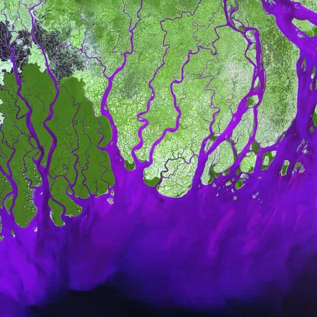
    Ganges River Delta. The Ganges River forms an extensive delta where it empties into the Bay of Bengal. The delta is largely covered with a swamp forest known as the Sunderbans, which is home to the Royal Bengal Tiger. It is also home to most of Bangladesh, one of the world’s most densely populated countries. Roughly 120 million people live on the Ganges Delta under threat of repeated catastrophic floods due to heavy runoff of meltwater from the Himalayas, and due to the intense rainfall during the monsoon season. This is a false-color composite image made using green, infrared, and blue wavelengths. Image taken February 28, 2000, by Landsat 7. (Photo by NASA/GSFC/USGS EROS Data Center)


    Ganges River Delta. The Ganges River forms an extensive delta where it empties into the Bay of Bengal. The delta is largely covered with a swamp forest known as the Sunderbans, which is home to the Royal Bengal Tiger. It is also home to most of Bangladesh, one of the world’s most densely populated countries. Roughly 120 million people live on the Ganges Delta under threat of repeated catastrophic floods due to heavy runoff of meltwater from the Himalayas, and due to the intense rainfall during the monsoon season. This is a false-color composite image made using green, infrared, and blue wavelengths. Image taken February 28, 2000, by Landsat 7. (Photo by NASA/GSFC/USGS EROS Data Center)


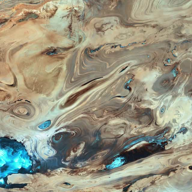
    Dasht-e Kavir, Iran. Like poster paints run wild, this image reveals an eclectic montage of landscapes in Iran’s largest desert, the Dasht-e Kavir, or Great Salt Desert. The word [kavir] is Persian for [salt marsh]. The almost uninhabited region covers an area of more than 77,000 square kilometres and is a mix of dry streambeds, desert plateaus, mudflats, and salt marshes. Extreme heat, dramatic daily temperature swings, and violent storms are the norm in this inhospitable place. Image taken February 10, 2003, by Landsat 7. (Photo by NASA/GSFC/USGS EROS Data Center)


    Dasht-e Kavir, Iran. Like poster paints run wild, this image reveals an eclectic montage of landscapes in Iran’s largest desert, the Dasht-e Kavir, or Great Salt Desert. The word [kavir] is Persian for [salt marsh]. The almost uninhabited region covers an area of more than 77,000 square kilometres and is a mix of dry streambeds, desert plateaus, mudflats, and salt marshes. Extreme heat, dramatic daily temperature swings, and violent storms are the norm in this inhospitable place. Image taken February 10, 2003, by Landsat 7. (Photo by NASA/GSFC/USGS EROS Data Center)


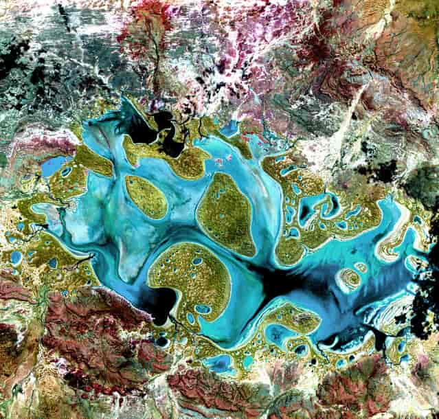
    Lake Carnegie. Ephemeral Lake Carnegie, in Western Australia, fills with water only during periods of significant rainfall. In dry years, it is reduced to a muddy marsh. This image was acquired on May 19, 1999, by Landsat 7′s Enhanced Thematic Mapper plus (ETM+) sensor.
This is a false-color composite image made using shortwave infrared, infrared, and red wavelengths, and has been sharpened using the sensor’s panchromatic band. (Photo by NASA/GSFC/USGS EROS Data Center)


    Lake Carnegie. Ephemeral Lake Carnegie, in Western Australia, fills with water only during periods of significant rainfall. In dry years, it is reduced to a muddy marsh. This image was acquired on May 19, 1999, by Landsat 7′s Enhanced Thematic Mapper plus (ETM+) sensor.
    This is a false-color composite image made using shortwave infrared, infrared, and red wavelengths, and has been sharpened using the sensor’s panchromatic band. (Photo by NASA/GSFC/USGS EROS Data Center)


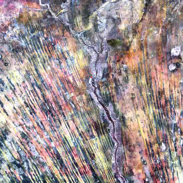
    On the edge of the Kalahari Desert in Namibia, sand dunes are encroaching onto once-fertile lands in the north. Healthy vegetation appears red in this image; in the center, notice the lone red dot. It is the result of a center-pivot irrigation system, evidence that at least one optimistic farmer continues to work the fields despite the approaching sand. This image was acquired by Landsat 7's Enhanced Thematic Mapper plus (ETM+) sensor on August 14, 2000. This is a false-color composite image made using near infrared, red, and green wavelengths. The image has also been sharpened using the sensor's panchromatic band. (Photo by NASA/GSFC/USGS EROS Data Center)


    On the edge of the Kalahari Desert in Namibia, sand dunes are encroaching onto once-fertile lands in the north. Healthy vegetation appears red in this image; in the center, notice the lone red dot. It is the result of a center-pivot irrigation system, evidence that at least one optimistic farmer continues to work the fields despite the approaching sand. This image was acquired by Landsat 7's Enhanced Thematic Mapper plus (ETM+) sensor on August 14, 2000. This is a false-color composite image made using near infrared, red, and green wavelengths. The image has also been sharpened using the sensor's panchromatic band. (Photo by NASA/GSFC/USGS EROS Data Center)


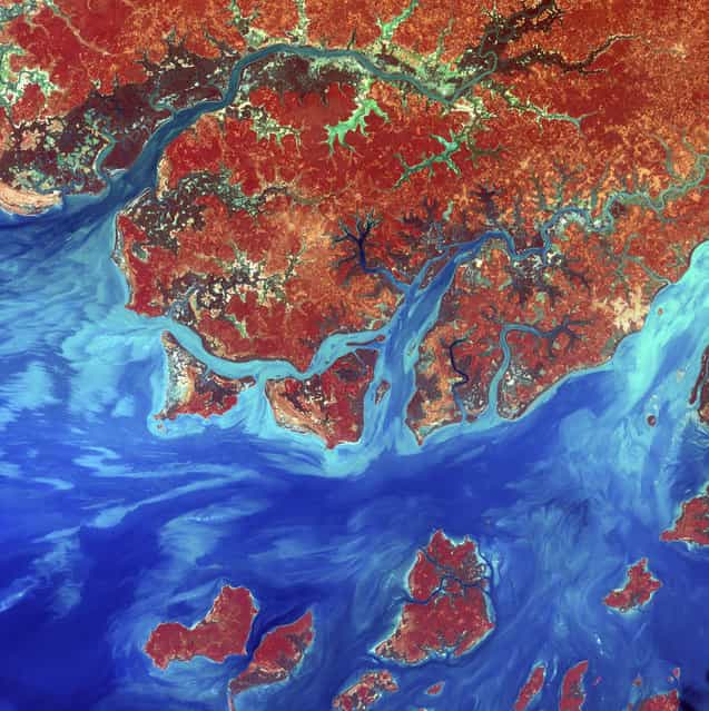
    Guinea-Bissau. Guinea-Bissau is a small country in West Africa. Complex patterns can be seen in the shallow waters along its coastline, where silt carried by the Geba and other rivers washes out into the Atlantic Ocean. This is a false-color composite image made using infrared, red and blue wavelengths to bring out details in the silt. Image taken December 1st, 2000, by Landsat 7. (Photo by NASA/GSFC/USGS EROS Data Center)


    Guinea-Bissau. Guinea-Bissau is a small country in West Africa. Complex patterns can be seen in the shallow waters along its coastline, where silt carried by the Geba and other rivers washes out into the Atlantic Ocean. This is a false-color composite image made using infrared, red and blue wavelengths to bring out details in the silt. Image taken December 1st, 2000, by Landsat 7. (Photo by NASA/GSFC/USGS EROS Data Center)


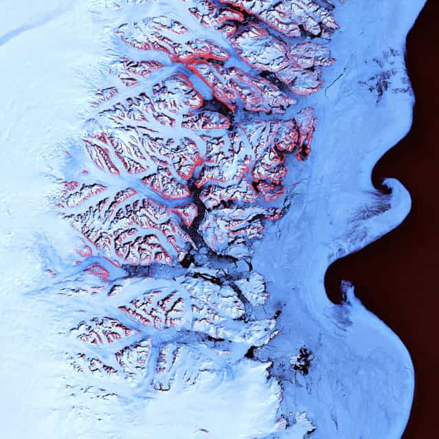
    Ice Waves, Greenland. Along the southeastern coast of Greenland, an intricate network of fjords funnels glacial ice to the Atlantic Ocean. During the summer melting season, newly calved icebergs join slabs of sea ice and older, weathered bergs in an offshore slurry that the southward-flowing East Greenland Current sometimes swirls into stunning shapes. Exposed rock of mountain peaks, tinted red in this image, hints at a hidden landscape. Image taken May 21, 2001, by Landsat 7. (Photo by NASA/GSFC/USGS EROS Data Center)


    Ice Waves, Greenland. Along the southeastern coast of Greenland, an intricate network of fjords funnels glacial ice to the Atlantic Ocean. During the summer melting season, newly calved icebergs join slabs of sea ice and older, weathered bergs in an offshore slurry that the southward-flowing East Greenland Current sometimes swirls into stunning shapes. Exposed rock of mountain peaks, tinted red in this image, hints at a hidden landscape. Image taken May 21, 2001, by Landsat 7. (Photo by NASA/GSFC/USGS EROS Data Center)


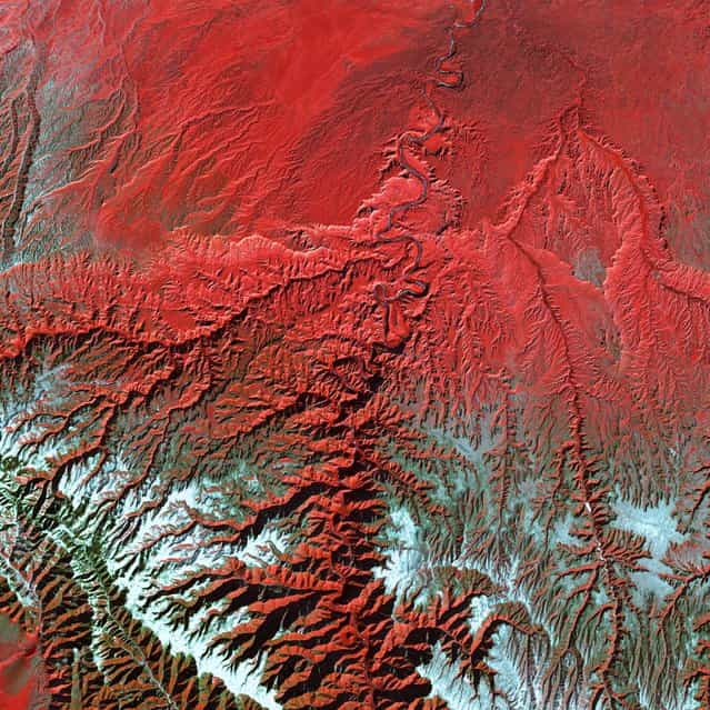
    Utah’s Green River cuts across the Tavaputs Plateau (top) before entering rugged Desolation Canyon (center), which cuts southward through first the Roan and then the Book Cliffs – two long, staircase-like escarpments that run west-east from Utah into Colorado. Desolation Canyon, seen in the center of this image, was named by the famous American explorer John Wesley Powell, for its intimidating, rugged terrain. Eighty miles long and nearly as deep as the Grand Canyon, it is one of the largest unprotected wilderness areas in the West. This image shows the Green River cutting a path through the vegetation of the Plateau. The river appears blue while the vegetation is red. Snow dusts the peaks of the Roan Cliffs, which appears light blue to white. This image was acquired by Landsat 7’s Enhanced Thematic Mapper plus (ETM+) sensor on December 31, 2000. This is a false-color composite image made using near-infrared, red, and green wavelengths. The image has also been sharpened using the sensor’s panchromatic band. (Photo by NASA/GSFC/USGS EROS Data Center)


    Utah’s Green River cuts across the Tavaputs Plateau (top) before entering rugged Desolation Canyon (center), which cuts southward through first the Roan and then the Book Cliffs – two long, staircase-like escarpments that run west-east from Utah into Colorado. Desolation Canyon, seen in the center of this image, was named by the famous American explorer John Wesley Powell, for its intimidating, rugged terrain. Eighty miles long and nearly as deep as the Grand Canyon, it is one of the largest unprotected wilderness areas in the West. This image shows the Green River cutting a path through the vegetation of the Plateau. The river appears blue while the vegetation is red. Snow dusts the peaks of the Roan Cliffs, which appears light blue to white. This image was acquired by Landsat 7’s Enhanced Thematic Mapper plus (ETM+) sensor on December 31, 2000. This is a false-color composite image made using near-infrared, red, and green wavelengths. The image has also been sharpened using the sensor’s panchromatic band. (Photo by NASA/GSFC/USGS EROS Data Center)


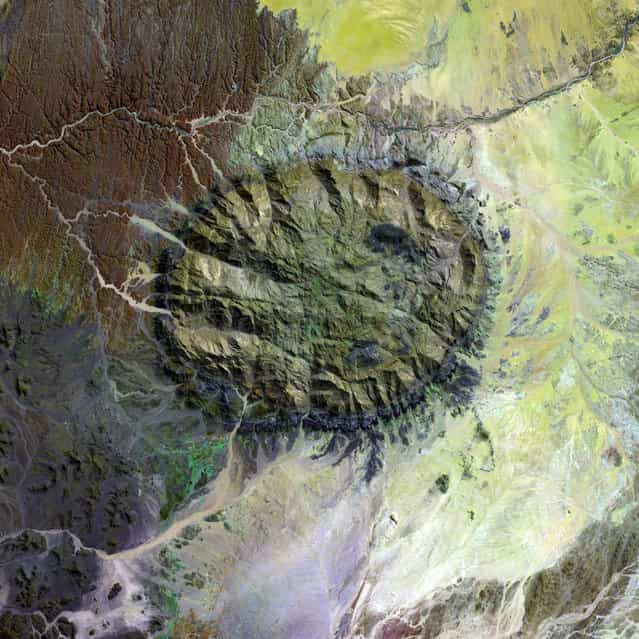
    Over 120 million years ago, a single mass of granite punched through the Earth’s crust and intruded into the heart of the Namib Desert in what is now northern Namibia. Today the mountain of rock called the Brandberg Massif towers over the arid desert below. A ring of dark, steep-sided rocks forced upward during the mountain’s arrival encircles the granite intruder. Its volcanism has long since stilled, but the granite core left behind apparently glows red in the light of the setting sun. The formation is a remnant of a long period of tumultuous volcanic and geologic activity on Earth during which the southern super-continent of Gondwana was splitting apart. The mountain influences the local climate, drawing more rain to its flanks than the desert below receives. The rain filters into the mountain’s deep crevices and slowly seeps out through springs. Unique plant and animal communities thrive in its high-altitude environment, and prehistoric cave paintings decorate walls hidden in the steep cliffs that gouge the mountain. To the southwest of Brandberg Massif, an older and more-eroded granite intrusion blends in subtly with the desert landscape, while along the Ugab River at upper left, cracks line the brown face of an ancient plain of rock transformed into gneiss by heat, pressure, and time. This image was acquired by Landsat 7’s Enhanced Thematic Mapper plus (ETM+) sensor. (Photo by NASA/GSFC/USGS EROS Data Center)


    Over 120 million years ago, a single mass of granite punched through the Earth’s crust and intruded into the heart of the Namib Desert in what is now northern Namibia. Today the mountain of rock called the Brandberg Massif towers over the arid desert below. A ring of dark, steep-sided rocks forced upward during the mountain’s arrival encircles the granite intruder. Its volcanism has long since stilled, but the granite core left behind apparently glows red in the light of the setting sun. The formation is a remnant of a long period of tumultuous volcanic and geologic activity on Earth during which the southern super-continent of Gondwana was splitting apart. The mountain influences the local climate, drawing more rain to its flanks than the desert below receives. The rain filters into the mountain’s deep crevices and slowly seeps out through springs. Unique plant and animal communities thrive in its high-altitude environment, and prehistoric cave paintings decorate walls hidden in the steep cliffs that gouge the mountain. To the southwest of Brandberg Massif, an older and more-eroded granite intrusion blends in subtly with the desert landscape, while along the Ugab River at upper left, cracks line the brown face of an ancient plain of rock transformed into gneiss by heat, pressure, and time. This image was acquired by Landsat 7’s Enhanced Thematic Mapper plus (ETM+) sensor. (Photo by NASA/GSFC/USGS EROS Data Center)


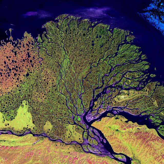
    Lena River Delta. The Lena River, some 4,500 km long, is one of the largest rivers in the world. The Lena Delta Reserve is the most extensive protected wilderness area in Russia. It is an important refuge and breeding ground for many species of Siberian wildlife. This is a false-color composite image made using shortwave infrared, infrared, and red wavelengths. Image taken July 27, 2000, by Landsat 7. (Photo by NASA/GSFC/USGS EROS Data Center)


    Lena River Delta. The Lena River, some 4,500 km long, is one of the largest rivers in the world. The Lena Delta Reserve is the most extensive protected wilderness area in Russia. It is an important refuge and breeding ground for many species of Siberian wildlife. This is a false-color composite image made using shortwave infrared, infrared, and red wavelengths. Image taken July 27, 2000, by Landsat 7. (Photo by NASA/GSFC/USGS EROS Data Center)


    Meandering Mississippi. Small, blocky shapes of towns, fields, and pastures surround the graceful swirls and whorls of the Mississippi River. Countless oxbow lakes and cutoffs accompany the meandering river south of Memphis, Tennessee, on the border between Arkansas and Mississippi, USA. The [mighty Mississippi] is the largest river system in North America. This image, taken by Landsat 7 on May 28, 2003, won 3rd place in the online [Earth as Art] competition to celebrate the 40th anniversary of the Landsat satellite program. (Photo by NASA/GSFC/USGS EROS Data Center)


    Meandering Mississippi. Small, blocky shapes of towns, fields, and pastures surround the graceful swirls and whorls of the Mississippi River. Countless oxbow lakes and cutoffs accompany the meandering river south of Memphis, Tennessee, on the border between Arkansas and Mississippi, USA. The [mighty Mississippi] is the largest river system in North America. This image, taken by Landsat 7 on May 28, 2003, won 3rd place in the online [Earth as Art] competition to celebrate the 40th anniversary of the Landsat satellite program. (Photo by NASA/GSFC/USGS EROS Data Center)


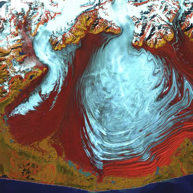
    Malaspina Glacier, Alaska. The tongue of the Malaspina Glacier, one of the largest piedmont glaciers in the world, fills most of this image. The Malaspina lies west of Yakutat Bay in Alaska and covers roughly 3,900 sq km. This image was acquired on August 31, 2000, by Landsat 7′s Enhanced Thematic Mapper plus (ETM+) sensor. This is a false-color composite image made using infrared, near infrared, and green wavelengths, and has been sharpened using the sensor’s panchromatic band. (Photo by NASA/GSFC/USGS EROS Data Center)


    Malaspina Glacier, Alaska. The tongue of the Malaspina Glacier, one of the largest piedmont glaciers in the world, fills most of this image. The Malaspina lies west of Yakutat Bay in Alaska and covers roughly 3,900 sq km. This image was acquired on August 31, 2000, by Landsat 7′s Enhanced Thematic Mapper plus (ETM+) sensor. This is a false-color composite image made using infrared, near infrared, and green wavelengths, and has been sharpened using the sensor’s panchromatic band. (Photo by NASA/GSFC/USGS EROS Data Center)


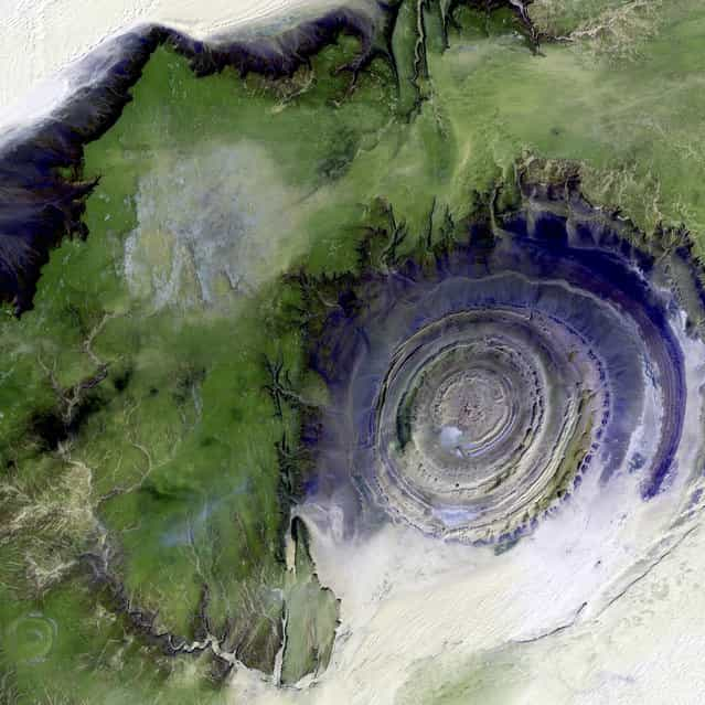
    Richat Structure, Mauritania. The so-called Richat Structure is a geological formation in the Maur Adrar Desert in the African country of Mauritania. Although it resembles an impact crater, the Richat Structure formed when a volcanic dome hardened and gradually eroded, exposing the onion-like layers of rock. This image was acquired on January 11, 2001, by Landsat 7′s Enhanced Thematic Mapper plus (ETM+) sensor. This is a false-color composite image made using shortwave infrared, infrared, and green wavelengths, and has been sharpened using the sensor’s panchromatic band. (Photo by NASA/GSFC/USGS EROS Data Center)


    Richat Structure, Mauritania. The so-called Richat Structure is a geological formation in the Maur Adrar Desert in the African country of Mauritania. Although it resembles an impact crater, the Richat Structure formed when a volcanic dome hardened and gradually eroded, exposing the onion-like layers of rock. This image was acquired on January 11, 2001, by Landsat 7′s Enhanced Thematic Mapper plus (ETM+) sensor. This is a false-color composite image made using shortwave infrared, infrared, and green wavelengths, and has been sharpened using the sensor’s panchromatic band. (Photo by NASA/GSFC/USGS EROS Data Center)


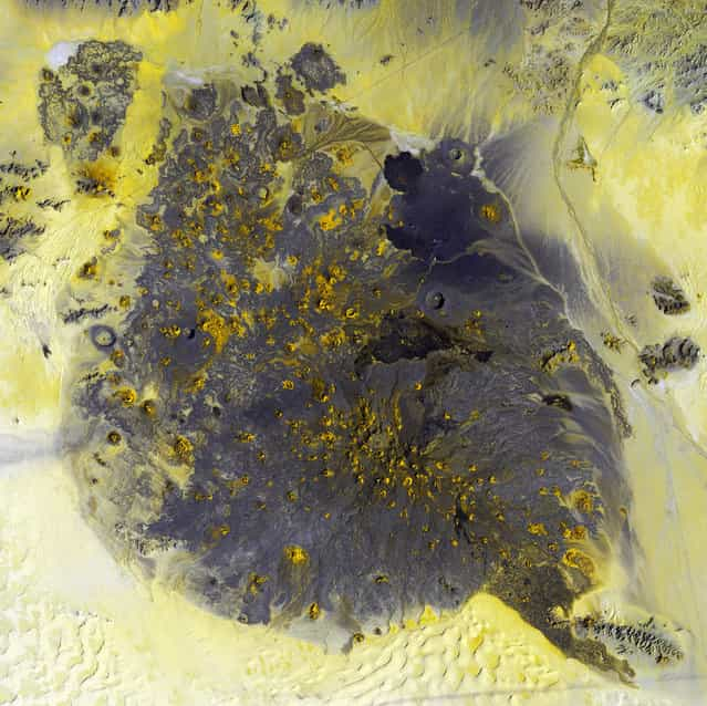
    Pinacate Volcano Field. Pinacate National Park and Biosphere Reserve is a 2,000-square-kilometer volcanic field in the Sonora province of Mexico, near the Arizona border. Surrounded by the Sonora Desert, this field contains more than 300 volcanic vents and cinder cones, including at least 10 maar craters. Maar eruptions are a rare form of volcano that erupts violently when rising magma meets underground water, producing a pocket of highly pressurized steam that blows a nearly circular hole in the crust above. The largest crater in the Pinacate field is Cerro Elegante, a maar crater about a kilometer in diameter. Image taken December 5, 2002, by Landsat 7. (Photo by NASA/GSFC/USGS EROS Data Center)


    Pinacate Volcano Field. Pinacate National Park and Biosphere Reserve is a 2,000-square-kilometer volcanic field in the Sonora province of Mexico, near the Arizona border. Surrounded by the Sonora Desert, this field contains more than 300 volcanic vents and cinder cones, including at least 10 maar craters. Maar eruptions are a rare form of volcano that erupts violently when rising magma meets underground water, producing a pocket of highly pressurized steam that blows a nearly circular hole in the crust above. The largest crater in the Pinacate field is Cerro Elegante, a maar crater about a kilometer in diameter. Image taken December 5, 2002, by Landsat 7. (Photo by NASA/GSFC/USGS EROS Data Center)


    Paraná River Delta. The Paraná River delta is a huge forested marshland about 30 km northeast of Buenos Aires, Argentina. The area is a very popular tour destination. Guided boat tours can be taken into this vast labyrinth of marsh and trees. The Paraná River delta is also one of the world’s greatest bird-watching destinations. This image highlights the striking contrast between dense forest and wetland marshes, and the deep blue ribbon of the Paraná River. Image taken May 26, 2000, by Landsat 7. (Photo by NASA/GSFC/USGS EROS Data Center)


    Paraná River Delta. The Paraná River delta is a huge forested marshland about 30 km northeast of Buenos Aires, Argentina. The area is a very popular tour destination. Guided boat tours can be taken into this vast labyrinth of marsh and trees. The Paraná River delta is also one of the world’s greatest bird-watching destinations. This image highlights the striking contrast between dense forest and wetland marshes, and the deep blue ribbon of the Paraná River. Image taken May 26, 2000, by Landsat 7. (Photo by NASA/GSFC/USGS EROS Data Center)


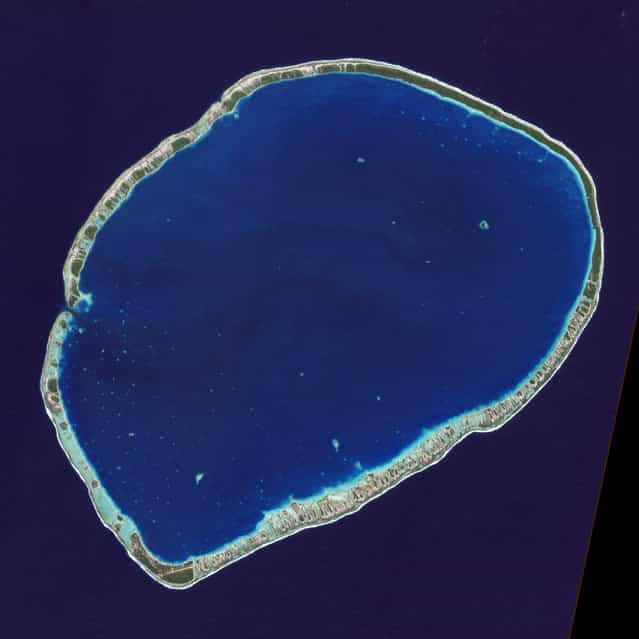
    The islands and coral atolls of French Polynesia, located in the southern Pacific Ocean, epitomize the idea of tropical paradise: white sandy beaches, turquoise lagoons, and palm trees. Even from the distance of space, the view of these atolls is beautiful. This image from the Advanced Land Imager on NASA’s Earth Observing-1 (EO-1) satellite shows the southern part of Tikehau Atoll, one of the 78 coral atolls that make up the Tuamotu Archipelago. Patches of coral make star-like spots across the turquoise expanse of the lagoon. A line of tree-covered islets encircles the lagoon. At the southernmost tip of the atoll, a large islet accommodates a small village and an air strip. (Photo by NASA/GSFC/USGS EROS Data Center)


    The islands and coral atolls of French Polynesia, located in the southern Pacific Ocean, epitomize the idea of tropical paradise: white sandy beaches, turquoise lagoons, and palm trees. Even from the distance of space, the view of these atolls is beautiful. This image from the Advanced Land Imager on NASA’s Earth Observing-1 (EO-1) satellite shows the southern part of Tikehau Atoll, one of the 78 coral atolls that make up the Tuamotu Archipelago. Patches of coral make star-like spots across the turquoise expanse of the lagoon. A line of tree-covered islets encircles the lagoon. At the southernmost tip of the atoll, a large islet accommodates a small village and an air strip. (Photo by NASA/GSFC/USGS EROS Data Center)


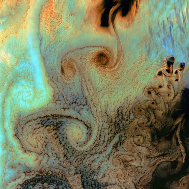
    Von Karman Vortices. As air flows over and around objects in its path, spiraling eddies, known as Von Karman vortices, may form. The vortices in this image, taken by Landsat 7 on July 4th, 2002, were created when prevailing winds sweeping east across the northern Pacific Ocean encountered Alaska’s Aleutian Islands. (Photo by NASA/GSFC/USGS EROS Data Center)
    Von Karman Vortices. As air flows over and around objects in its path, spiraling eddies, known as Von Karman vortices, may form. The vortices in this image, taken by Landsat 7 on July 4th, 2002, were created when prevailing winds sweeping east across the northern Pacific Ocean encountered Alaska’s Aleutian Islands. (Photo by NASA/GSFC/USGS EROS Data Center)


    Add Comments
    Bold Italic Underline Strike | Align left Center Align right | Insert smilies Select color | Add Hidden Text Insert Quote Convert selected text from selection to Cyrillic (Russian) alphabet Insert spoiler

    It is forbidden to use not normative lexicon, insult other users of the site, active links to other sites, advertising in the comments..

Advertisements:

photo news
Advertisements


[Earth as Art] (in Hi-Res)


Bombetoka Bay, Madagascar. On the northwestern coast of Madagascar, the salty waters of the Mozambique Channel penetrate inland to join with the freshwater outflow of the Betsiboka River, forming Bombetoka Bay. Numerous islands and sandbars have formed in the estuary from the large amount of sediment carried in by the Betsiboka River and have been shaped by the flow of the river and the push and pull of tides. This image from the Advanced Spaceborne Thermal Emission and Reflection Radiometer (ASTER) on NASA's Terra satellite shows Bombetoka Bay just upstream of where it opens up into the Mozambique Channel, which separates Madagascar from Africa to the west. In the image, water is sapphire and tinged with pink where sediment is particularly thick. Dense vegetation is deep green. Along coastlines and on the islands, the vegetation is predominantly mangrove forests. In fact, Bombetoka Bay is home to some of Madagascar's largest remaining communities of mangroves, which provide shelter for diverse mollusk and crustacean communities, as well as habitat for sea turtles, birds, and dugongs. Along the northwest coast of Madagascar, mangroves and coral reefs partner up to create dynamic, diverse coastal ecosystems. The mangrove forests capture river-borne sediment that would smother coastal reefs, while reefs buffer the mangroves from pounding surf. (Photo by NASA/GSFC/USGS EROS Data Center)


Bombetoka Bay, Madagascar. On the northwestern coast of Madagascar, the salty waters of the Mozambique Channel penetrate inland to join with the freshwater outflow of the Betsiboka River, forming Bombetoka Bay. Numerous islands and sandbars have formed in the estuary from the large amount of sediment carried in by the Betsiboka River and have been shaped by the flow of the river and the push and pull of tides. This image from the Advanced Spaceborne Thermal Emission and Reflection Radiometer (ASTER) on NASA's Terra satellite shows Bombetoka Bay just upstream of where it opens up into the Mozambique Channel, which separates Madagascar from Africa to the west. In the image, water is sapphire and tinged with pink where sediment is particularly thick. Dense vegetation is deep green. Along coastlines and on the islands, the vegetation is predominantly mangrove forests. In fact, Bombetoka Bay is home to some of Madagascar's largest remaining communities of mangroves, which provide shelter for diverse mollusk and crustacean communities, as well as habitat for sea turtles, birds, and dugongs. Along the northwest coast of Madagascar, mangroves and coral reefs partner up to create dynamic, diverse coastal ecosystems. The mangrove forests capture river-borne sediment that would smother coastal reefs, while reefs buffer the mangroves from pounding surf. (Photo by NASA/GSFC/USGS EROS Data Center)


Bogda Mountains. The Turpan Depression, nestled at the foot of China’s Bogda Mountains, is a strange mix of salt lakes and sand dunes. It is one of the few landscapes in the world that lies below sea level. This image was acquired by Landsat 7’s Enhanced Thematic Mapper plus (ETM+) sensor. (Photo by NASA/GSFC/USGS EROS Data Center)


Bogda Mountains. The Turpan Depression, nestled at the foot of China’s Bogda Mountains, is a strange mix of salt lakes and sand dunes. It is one of the few landscapes in the world that lies below sea level. This image was acquired by Landsat 7’s Enhanced Thematic Mapper plus (ETM+) sensor. (Photo by NASA/GSFC/USGS EROS Data Center)


Meandering wadis combine to form dense, branching networks across the stark, arid landscape of southeastern Jordan. The Arabic word [wadi] means a gulley or streambed that typically remains dry except after drenching, seasonal rains. This scene was acquired by the ASTER instrument on NASA's Terra satellite on May 17, 2001. (Photo by NASA/GSFC/USGS EROS Data Center)


Meandering wadis combine to form dense, branching networks across the stark, arid landscape of southeastern Jordan. The Arabic word [wadi] means a gulley or streambed that typically remains dry except after drenching, seasonal rains. This scene was acquired by the ASTER instrument on NASA's Terra satellite on May 17, 2001. (Photo by NASA/GSFC/USGS EROS Data Center)


Akpatok Island, Canada. Akpatok Island lies in Ungava Bay in northern Quebec, Canada. Accessible only by air, the island rises out of the water as sheer cliffs that soar 150 to 243 m above the sea surface. Akpatok Island is an important sanctuary for cliff-nesting seabirds. Numerous ice floes around the island attract walrus and whales, making Akpatok a traditional hunting ground for native Inuit people. Image taken January 22, 2001, by Landsat 7. (Photo by NASA/GSFC/USGS EROS Data Center)


Akpatok Island, Canada. Akpatok Island lies in Ungava Bay in northern Quebec, Canada. Accessible only by air, the island rises out of the water as sheer cliffs that soar 150 to 243 m above the sea surface. Akpatok Island is an important sanctuary for cliff-nesting seabirds. Numerous ice floes around the island attract walrus and whales, making Akpatok a traditional hunting ground for native Inuit people. Image taken January 22, 2001, by Landsat 7. (Photo by NASA/GSFC/USGS EROS Data Center)


Alluvial Fan, China. A vast alluvial fan blossoms across the desolate landscape between the Kunlun and Altun mountain ranges that form the southern border of the Taklimakan Desert in China’s XinJiang Province. Image taken by the ASTER instrument on NASA’s Terra satellite on May 2nd, 2002. (Photo by NASA/GSFC/USGS EROS Data Center)


Alluvial Fan, China. A vast alluvial fan blossoms across the desolate landscape between the Kunlun and Altun mountain ranges that form the southern border of the Taklimakan Desert in China’s XinJiang Province. Image taken by the ASTER instrument on NASA’s Terra satellite on May 2nd, 2002. (Photo by NASA/GSFC/USGS EROS Data Center)


Delta Region, Netherlands. Along the southern coast of the Netherlands, sediment-laden rivers have created a massive delta of islands and waterways in the gaps between coastal dunes. After unusually severe spring tides devastated this region in 1953, the Dutch built an elaborate system of dikes, canals, dams, bridges, and locks to hold back the North Sea. Image taken on September 24, 2002, by the ASTER instrument aboard NASA’s Terra satellite. (Photo by NASA/GSFC/USGS EROS Data Center)


Delta Region, Netherlands. Along the southern coast of the Netherlands, sediment-laden rivers have created a massive delta of islands and waterways in the gaps between coastal dunes. After unusually severe spring tides devastated this region in 1953, the Dutch built an elaborate system of dikes, canals, dams, bridges, and locks to hold back the North Sea. Image taken on September 24, 2002, by the ASTER instrument aboard NASA’s Terra satellite. (Photo by NASA/GSFC/USGS EROS Data Center)


Yukon Delta. After beginning in northern British Columbia and flowing through Yukon in Canada, the Yukon River crosses Alaska, USA, before emptying into the Bering Sea. Countless lakes, sloughs, and ponds are scattered throughout this scene of the Yukon Delta. The river’s sinuous waterways seem like blood vessels branching out to enclose an organ. The Yukon Delta is one of the largest river deltas in the world, and currently protected as part of its own National Wildlife Refuge. This image, taken by Landsat 7 on September 22, 2002, won 2nd place in the online [Earth as Art] competition to celebrate the 40th anniversary of the Landsat satellite program. (Photo by NASA/GSFC/USGS EROS Data Center)


Yukon Delta. After beginning in northern British Columbia and flowing through Yukon in Canada, the Yukon River crosses Alaska, USA, before emptying into the Bering Sea. Countless lakes, sloughs, and ponds are scattered throughout this scene of the Yukon Delta. The river’s sinuous waterways seem like blood vessels branching out to enclose an organ. The Yukon Delta is one of the largest river deltas in the world, and currently protected as part of its own National Wildlife Refuge. This image, taken by Landsat 7 on September 22, 2002, won 2nd place in the online [Earth as Art] competition to celebrate the 40th anniversary of the Landsat satellite program. (Photo by NASA/GSFC/USGS EROS Data Center)


Dasht-e Kavir, Iran. The Dasht-e Kavir, or Great Salt Desert, is the larger of Iran's two major deserts, which occupy most of the country's central plateau. Located in north-central Iran, the mostly uninhabited desert is about 800km long and 320km wide. Once situated beneath an ancient inland sea, the arid region is now covered with salt deposits and is known for its salt marshes (kavirs), which can act like quicksand. From wild sheep and leopards to gazelles and lizards, there is a range of wildlife in the mountainous areas and parts of the steppe and desert areas of the central plateau. This 2000 Landsat 7 image shows the intricately folded sediments and colourful formations that now blanket the surface of this barren landscape. (Photo by NASA/GSFC/USGS EROS Data Center)


Dasht-e Kavir, Iran. The Dasht-e Kavir, or Great Salt Desert, is the larger of Iran's two major deserts, which occupy most of the country's central plateau. Located in north-central Iran, the mostly uninhabited desert is about 800km long and 320km wide. Once situated beneath an ancient inland sea, the arid region is now covered with salt deposits and is known for its salt marshes (kavirs), which can act like quicksand. From wild sheep and leopards to gazelles and lizards, there is a range of wildlife in the mountainous areas and parts of the steppe and desert areas of the central plateau. This 2000 Landsat 7 image shows the intricately folded sediments and colourful formations that now blanket the surface of this barren landscape. (Photo by NASA/GSFC/USGS EROS Data Center)


Ganges River Delta. The Ganges River forms an extensive delta where it empties into the Bay of Bengal. The delta is largely covered with a swamp forest known as the Sunderbans, which is home to the Royal Bengal Tiger. It is also home to most of Bangladesh, one of the world’s most densely populated countries. Roughly 120 million people live on the Ganges Delta under threat of repeated catastrophic floods due to heavy runoff of meltwater from the Himalayas, and due to the intense rainfall during the monsoon season. This is a false-color composite image made using green, infrared, and blue wavelengths. Image taken February 28, 2000, by Landsat 7. (Photo by NASA/GSFC/USGS EROS Data Center)


Ganges River Delta. The Ganges River forms an extensive delta where it empties into the Bay of Bengal. The delta is largely covered with a swamp forest known as the Sunderbans, which is home to the Royal Bengal Tiger. It is also home to most of Bangladesh, one of the world’s most densely populated countries. Roughly 120 million people live on the Ganges Delta under threat of repeated catastrophic floods due to heavy runoff of meltwater from the Himalayas, and due to the intense rainfall during the monsoon season. This is a false-color composite image made using green, infrared, and blue wavelengths. Image taken February 28, 2000, by Landsat 7. (Photo by NASA/GSFC/USGS EROS Data Center)


Dasht-e Kavir, Iran. Like poster paints run wild, this image reveals an eclectic montage of landscapes in Iran’s largest desert, the Dasht-e Kavir, or Great Salt Desert. The word [kavir] is Persian for [salt marsh]. The almost uninhabited region covers an area of more than 77,000 square kilometres and is a mix of dry streambeds, desert plateaus, mudflats, and salt marshes. Extreme heat, dramatic daily temperature swings, and violent storms are the norm in this inhospitable place. Image taken February 10, 2003, by Landsat 7. (Photo by NASA/GSFC/USGS EROS Data Center)


Dasht-e Kavir, Iran. Like poster paints run wild, this image reveals an eclectic montage of landscapes in Iran’s largest desert, the Dasht-e Kavir, or Great Salt Desert. The word [kavir] is Persian for [salt marsh]. The almost uninhabited region covers an area of more than 77,000 square kilometres and is a mix of dry streambeds, desert plateaus, mudflats, and salt marshes. Extreme heat, dramatic daily temperature swings, and violent storms are the norm in this inhospitable place. Image taken February 10, 2003, by Landsat 7. (Photo by NASA/GSFC/USGS EROS Data Center)


Lake Carnegie. Ephemeral Lake Carnegie, in Western Australia, fills with water only during periods of significant rainfall. In dry years, it is reduced to a muddy marsh. This image was acquired on May 19, 1999, by Landsat 7′s Enhanced Thematic Mapper plus (ETM+) sensor.
This is a false-color composite image made using shortwave infrared, infrared, and red wavelengths, and has been sharpened using the sensor’s panchromatic band. (Photo by NASA/GSFC/USGS EROS Data Center)


On the edge of the Kalahari Desert in Namibia, sand dunes are encroaching onto once-fertile lands in the north. Healthy vegetation appears red in this image; in the center, notice the lone red dot. It is the result of a center-pivot irrigation system, evidence that at least one optimistic farmer continues to work the fields despite the approaching sand. This image was acquired by Landsat 7's Enhanced Thematic Mapper plus (ETM+) sensor on August 14, 2000. This is a false-color composite image made using near infrared, red, and green wavelengths. The image has also been sharpened using the sensor's panchromatic band. (Photo by NASA/GSFC/USGS EROS Data Center)


On the edge of the Kalahari Desert in Namibia, sand dunes are encroaching onto once-fertile lands in the north. Healthy vegetation appears red in this image; in the center, notice the lone red dot. It is the result of a center-pivot irrigation system, evidence that at least one optimistic farmer continues to work the fields despite the approaching sand. This image was acquired by Landsat 7's Enhanced Thematic Mapper plus (ETM+) sensor on August 14, 2000. This is a false-color composite image made using near infrared, red, and green wavelengths. The image has also been sharpened using the sensor's panchromatic band. (Photo by NASA/GSFC/USGS EROS Data Center)


Guinea-Bissau. Guinea-Bissau is a small country in West Africa. Complex patterns can be seen in the shallow waters along its coastline, where silt carried by the Geba and other rivers washes out into the Atlantic Ocean. This is a false-color composite image made using infrared, red and blue wavelengths to bring out details in the silt. Image taken December 1st, 2000, by Landsat 7. (Photo by NASA/GSFC/USGS EROS Data Center)


Guinea-Bissau. Guinea-Bissau is a small country in West Africa. Complex patterns can be seen in the shallow waters along its coastline, where silt carried by the Geba and other rivers washes out into the Atlantic Ocean. This is a false-color composite image made using infrared, red and blue wavelengths to bring out details in the silt. Image taken December 1st, 2000, by Landsat 7. (Photo by NASA/GSFC/USGS EROS Data Center)


Ice Waves, Greenland. Along the southeastern coast of Greenland, an intricate network of fjords funnels glacial ice to the Atlantic Ocean. During the summer melting season, newly calved icebergs join slabs of sea ice and older, weathered bergs in an offshore slurry that the southward-flowing East Greenland Current sometimes swirls into stunning shapes. Exposed rock of mountain peaks, tinted red in this image, hints at a hidden landscape. Image taken May 21, 2001, by Landsat 7. (Photo by NASA/GSFC/USGS EROS Data Center)


Ice Waves, Greenland. Along the southeastern coast of Greenland, an intricate network of fjords funnels glacial ice to the Atlantic Ocean. During the summer melting season, newly calved icebergs join slabs of sea ice and older, weathered bergs in an offshore slurry that the southward-flowing East Greenland Current sometimes swirls into stunning shapes. Exposed rock of mountain peaks, tinted red in this image, hints at a hidden landscape. Image taken May 21, 2001, by Landsat 7. (Photo by NASA/GSFC/USGS EROS Data Center)


Utah’s Green River cuts across the Tavaputs Plateau (top) before entering rugged Desolation Canyon (center), which cuts southward through first the Roan and then the Book Cliffs – two long, staircase-like escarpments that run west-east from Utah into Colorado. Desolation Canyon, seen in the center of this image, was named by the famous American explorer John Wesley Powell, for its intimidating, rugged terrain. Eighty miles long and nearly as deep as the Grand Canyon, it is one of the largest unprotected wilderness areas in the West. This image shows the Green River cutting a path through the vegetation of the Plateau. The river appears blue while the vegetation is red. Snow dusts the peaks of the Roan Cliffs, which appears light blue to white. This image was acquired by Landsat 7’s Enhanced Thematic Mapper plus (ETM+) sensor on December 31, 2000. This is a false-color composite image made using near-infrared, red, and green wavelengths. The image has also been sharpened using the sensor’s panchromatic band. (Photo by NASA/GSFC/USGS EROS Data Center)


Utah’s Green River cuts across the Tavaputs Plateau (top) before entering rugged Desolation Canyon (center), which cuts southward through first the Roan and then the Book Cliffs – two long, staircase-like escarpments that run west-east from Utah into Colorado. Desolation Canyon, seen in the center of this image, was named by the famous American explorer John Wesley Powell, for its intimidating, rugged terrain. Eighty miles long and nearly as deep as the Grand Canyon, it is one of the largest unprotected wilderness areas in the West. This image shows the Green River cutting a path through the vegetation of the Plateau. The river appears blue while the vegetation is red. Snow dusts the peaks of the Roan Cliffs, which appears light blue to white. This image was acquired by Landsat 7’s Enhanced Thematic Mapper plus (ETM+) sensor on December 31, 2000. This is a false-color composite image made using near-infrared, red, and green wavelengths. The image has also been sharpened using the sensor’s panchromatic band. (Photo by NASA/GSFC/USGS EROS Data Center)


Over 120 million years ago, a single mass of granite punched through the Earth’s crust and intruded into the heart of the Namib Desert in what is now northern Namibia. Today the mountain of rock called the Brandberg Massif towers over the arid desert below. A ring of dark, steep-sided rocks forced upward during the mountain’s arrival encircles the granite intruder. Its volcanism has long since stilled, but the granite core left behind apparently glows red in the light of the setting sun. The formation is a remnant of a long period of tumultuous volcanic and geologic activity on Earth during which the southern super-continent of Gondwana was splitting apart. The mountain influences the local climate, drawing more rain to its flanks than the desert below receives. The rain filters into the mountain’s deep crevices and slowly seeps out through springs. Unique plant and animal communities thrive in its high-altitude environment, and prehistoric cave paintings decorate walls hidden in the steep cliffs that gouge the mountain. To the southwest of Brandberg Massif, an older and more-eroded granite intrusion blends in subtly with the desert landscape, while along the Ugab River at upper left, cracks line the brown face of an ancient plain of rock transformed into gneiss by heat, pressure, and time. This image was acquired by Landsat 7’s Enhanced Thematic Mapper plus (ETM+) sensor. (Photo by NASA/GSFC/USGS EROS Data Center)


Over 120 million years ago, a single mass of granite punched through the Earth’s crust and intruded into the heart of the Namib Desert in what is now northern Namibia. Today the mountain of rock called the Brandberg Massif towers over the arid desert below. A ring of dark, steep-sided rocks forced upward during the mountain’s arrival encircles the granite intruder. Its volcanism has long since stilled, but the granite core left behind apparently glows red in the light of the setting sun. The formation is a remnant of a long period of tumultuous volcanic and geologic activity on Earth during which the southern super-continent of Gondwana was splitting apart. The mountain influences the local climate, drawing more rain to its flanks than the desert below receives. The rain filters into the mountain’s deep crevices and slowly seeps out through springs. Unique plant and animal communities thrive in its high-altitude environment, and prehistoric cave paintings decorate walls hidden in the steep cliffs that gouge the mountain. To the southwest of Brandberg Massif, an older and more-eroded granite intrusion blends in subtly with the desert landscape, while along the Ugab River at upper left, cracks line the brown face of an ancient plain of rock transformed into gneiss by heat, pressure, and time. This image was acquired by Landsat 7’s Enhanced Thematic Mapper plus (ETM+) sensor. (Photo by NASA/GSFC/USGS EROS Data Center)


Lena River Delta. The Lena River, some 4,500 km long, is one of the largest rivers in the world. The Lena Delta Reserve is the most extensive protected wilderness area in Russia. It is an important refuge and breeding ground for many species of Siberian wildlife. This is a false-color composite image made using shortwave infrared, infrared, and red wavelengths. Image taken July 27, 2000, by Landsat 7. (Photo by NASA/GSFC/USGS EROS Data Center)


Lena River Delta. The Lena River, some 4,500 km long, is one of the largest rivers in the world. The Lena Delta Reserve is the most extensive protected wilderness area in Russia. It is an important refuge and breeding ground for many species of Siberian wildlife. This is a false-color composite image made using shortwave infrared, infrared, and red wavelengths. Image taken July 27, 2000, by Landsat 7. (Photo by NASA/GSFC/USGS EROS Data Center)


Meandering Mississippi. Small, blocky shapes of towns, fields, and pastures surround the graceful swirls and whorls of the Mississippi River. Countless oxbow lakes and cutoffs accompany the meandering river south of Memphis, Tennessee, on the border between Arkansas and Mississippi, USA. The [mighty Mississippi] is the largest river system in North America. This image, taken by Landsat 7 on May 28, 2003, won 3rd place in the online [Earth as Art] competition to celebrate the 40th anniversary of the Landsat satellite program. (Photo by NASA/GSFC/USGS EROS Data Center)


Meandering Mississippi. Small, blocky shapes of towns, fields, and pastures surround the graceful swirls and whorls of the Mississippi River. Countless oxbow lakes and cutoffs accompany the meandering river south of Memphis, Tennessee, on the border between Arkansas and Mississippi, USA. The [mighty Mississippi] is the largest river system in North America. This image, taken by Landsat 7 on May 28, 2003, won 3rd place in the online [Earth as Art] competition to celebrate the 40th anniversary of the Landsat satellite program. (Photo by NASA/GSFC/USGS EROS Data Center)


Malaspina Glacier, Alaska. The tongue of the Malaspina Glacier, one of the largest piedmont glaciers in the world, fills most of this image. The Malaspina lies west of Yakutat Bay in Alaska and covers roughly 3,900 sq km. This image was acquired on August 31, 2000, by Landsat 7′s Enhanced Thematic Mapper plus (ETM+) sensor. This is a false-color composite image made using infrared, near infrared, and green wavelengths, and has been sharpened using the sensor’s panchromatic band. (Photo by NASA/GSFC/USGS EROS Data Center)


Malaspina Glacier, Alaska. The tongue of the Malaspina Glacier, one of the largest piedmont glaciers in the world, fills most of this image. The Malaspina lies west of Yakutat Bay in Alaska and covers roughly 3,900 sq km. This image was acquired on August 31, 2000, by Landsat 7′s Enhanced Thematic Mapper plus (ETM+) sensor. This is a false-color composite image made using infrared, near infrared, and green wavelengths, and has been sharpened using the sensor’s panchromatic band. (Photo by NASA/GSFC/USGS EROS Data Center)


Richat Structure, Mauritania. The so-called Richat Structure is a geological formation in the Maur Adrar Desert in the African country of Mauritania. Although it resembles an impact crater, the Richat Structure formed when a volcanic dome hardened and gradually eroded, exposing the onion-like layers of rock. This image was acquired on January 11, 2001, by Landsat 7′s Enhanced Thematic Mapper plus (ETM+) sensor. This is a false-color composite image made using shortwave infrared, infrared, and green wavelengths, and has been sharpened using the sensor’s panchromatic band. (Photo by NASA/GSFC/USGS EROS Data Center)


Richat Structure, Mauritania. The so-called Richat Structure is a geological formation in the Maur Adrar Desert in the African country of Mauritania. Although it resembles an impact crater, the Richat Structure formed when a volcanic dome hardened and gradually eroded, exposing the onion-like layers of rock. This image was acquired on January 11, 2001, by Landsat 7′s Enhanced Thematic Mapper plus (ETM+) sensor. This is a false-color composite image made using shortwave infrared, infrared, and green wavelengths, and has been sharpened using the sensor’s panchromatic band. (Photo by NASA/GSFC/USGS EROS Data Center)


Pinacate Volcano Field. Pinacate National Park and Biosphere Reserve is a 2,000-square-kilometer volcanic field in the Sonora province of Mexico, near the Arizona border. Surrounded by the Sonora Desert, this field contains more than 300 volcanic vents and cinder cones, including at least 10 maar craters. Maar eruptions are a rare form of volcano that erupts violently when rising magma meets underground water, producing a pocket of highly pressurized steam that blows a nearly circular hole in the crust above. The largest crater in the Pinacate field is Cerro Elegante, a maar crater about a kilometer in diameter. Image taken December 5, 2002, by Landsat 7. (Photo by NASA/GSFC/USGS EROS Data Center)


Pinacate Volcano Field. Pinacate National Park and Biosphere Reserve is a 2,000-square-kilometer volcanic field in the Sonora province of Mexico, near the Arizona border. Surrounded by the Sonora Desert, this field contains more than 300 volcanic vents and cinder cones, including at least 10 maar craters. Maar eruptions are a rare form of volcano that erupts violently when rising magma meets underground water, producing a pocket of highly pressurized steam that blows a nearly circular hole in the crust above. The largest crater in the Pinacate field is Cerro Elegante, a maar crater about a kilometer in diameter. Image taken December 5, 2002, by Landsat 7. (Photo by NASA/GSFC/USGS EROS Data Center)


Paraná River Delta. The Paraná River delta is a huge forested marshland about 30 km northeast of Buenos Aires, Argentina. The area is a very popular tour destination. Guided boat tours can be taken into this vast labyrinth of marsh and trees. The Paraná River delta is also one of the world’s greatest bird-watching destinations. This image highlights the striking contrast between dense forest and wetland marshes, and the deep blue ribbon of the Paraná River. Image taken May 26, 2000, by Landsat 7. (Photo by NASA/GSFC/USGS EROS Data Center)


Paraná River Delta. The Paraná River delta is a huge forested marshland about 30 km northeast of Buenos Aires, Argentina. The area is a very popular tour destination. Guided boat tours can be taken into this vast labyrinth of marsh and trees. The Paraná River delta is also one of the world’s greatest bird-watching destinations. This image highlights the striking contrast between dense forest and wetland marshes, and the deep blue ribbon of the Paraná River. Image taken May 26, 2000, by Landsat 7. (Photo by NASA/GSFC/USGS EROS Data Center)


The islands and coral atolls of French Polynesia, located in the southern Pacific Ocean, epitomize the idea of tropical paradise: white sandy beaches, turquoise lagoons, and palm trees. Even from the distance of space, the view of these atolls is beautiful. This image from the Advanced Land Imager on NASA’s Earth Observing-1 (EO-1) satellite shows the southern part of Tikehau Atoll, one of the 78 coral atolls that make up the Tuamotu Archipelago. Patches of coral make star-like spots across the turquoise expanse of the lagoon. A line of tree-covered islets encircles the lagoon. At the southernmost tip of the atoll, a large islet accommodates a small village and an air strip. (Photo by NASA/GSFC/USGS EROS Data Center)


The islands and coral atolls of French Polynesia, located in the southern Pacific Ocean, epitomize the idea of tropical paradise: white sandy beaches, turquoise lagoons, and palm trees. Even from the distance of space, the view of these atolls is beautiful. This image from the Advanced Land Imager on NASA’s Earth Observing-1 (EO-1) satellite shows the southern part of Tikehau Atoll, one of the 78 coral atolls that make up the Tuamotu Archipelago. Patches of coral make star-like spots across the turquoise expanse of the lagoon. A line of tree-covered islets encircles the lagoon. At the southernmost tip of the atoll, a large islet accommodates a small village and an air strip. (Photo by NASA/GSFC/USGS EROS Data Center)


Von Karman Vortices. As air flows over and around objects in its path, spiraling eddies, known as Von Karman vortices, may form. The vortices in this image, taken by Landsat 7 on July 4th, 2002, were created when prevailing winds sweeping east across the northern Pacific Ocean encountered Alaska’s Aleutian Islands. (Photo by NASA/GSFC/USGS EROS Data Center)


Von Karman Vortices. As air flows over and around objects in its path, spiraling eddies, known as Von Karman vortices, may form. The vortices in this image, taken by Landsat 7 on July 4th, 2002, were created when prevailing winds sweeping east across the northern Pacific Ocean encountered Alaska’s Aleutian Islands. (Photo by NASA/GSFC/USGS EROS Data Center)


Add Comments
Bold Italic Underline Strike | Align left Center Align right | Insert smilies Select color | Add Hidden Text Insert Quote Convert selected text from selection to Cyrillic (Russian) alphabet Insert spoiler

It is forbidden to use not normative lexicon, insult other users of the site, active links to other sites, advertising in the comments..